“Ideally, new buildings in historic neighborhoods build on the place’s pre-existing narrative. They neither imitate nor snub it, but instead engage in a subtle architectural dialogue with the past. To achieve this requires a deep reading of the context and its significance. If a new project can’t contribute to the neighborhood’s narrative, then the next best hope is that it’s neutral to the neighborhood’s context; it neither adds to nor detracts from it. In other words, it doesn’t spoil the magic.” From “Building on the past: the Stockade District’s tipping point” by Marissa Marvelli in the Kingston Times.
By Rebecca Martin
The Kingstonian Project studies are now available on the City of Kingston’s website. There are nine of them: Cultural Resources, Visual Impacts, Traffic Impacts, Water and Sewer, Demolition, Stormwater, Habitat, Geotechnical and Green Concepts.
The next Kingston planning board meeting is Wednesday September 4th at 6:00pm. A generic agenda is up, but you can keep track by following our FACEBOOK EVENT for updated information. We’re expecting that the planning board will set a public comment period for the studies, though that information is not yet available.
Please follow KingstonCitizens.org (sign up for our newsletter on the front page of our website) and friend us on FACEBOOK for updated event information.
PHASE 1A CULTURAL RESOURCE INVESTIGATION KINGSTONIAN DEVELOPMENT 9-21 NORTH FRONT STREET
By Joseph E. Diamond, Ph.D.
“This cultural resource survey was conducted to evaluate a proposed combined 2.2 acre/.89 hectare redevelopment project in the City of Kingston, Ulster County, NY (Map 1 and 2). The project area is located on the northeast and northwestern corners at the junction of Fair and North Front Streets. This is an area commonly referred to as the “uptown” portion of Kingston, NY. The project area fronts on North Front Street and is split by Fair Street (Map 3). Photograph locations and directions of the project area are shown on Map 3. The proposed project area currently consists of an open parking lot of 1.4 acres/.57 hectares (Photograph 1) and a large four story building that is used for storage of various kinds of hardware (Photograph 2). North of the main building (which will be demolished, are a series of attached two story storage buildings from the mid-20th century (Photograph 3). A separate, but adjacent parcel to the north of the storage buildings is a modern diner (Photograph 4), which will also be demolished.
Impacts for the proposed project include the demolition of the main building, the low storage buildings attached to it and the diner on the east side of Fair Street. On the west side of Fair Street the removal of the blacktop parking lot will be the main impact, as well as excavation for footings and services. In addition a portion of an existing city street will be abandoned and utilized as part of the project. These impacts include include hookups to water, electricity, and sewer lines.
The author was contacted by Mr. Dennis Larios of Brinnier and Larios, P.C. in May of 2019. The background information for the sensitivity is a combination of a literature survey conducted at OPRHP on 10/25/05 by Kim Croshier of Croshier Archaeological Research as well as more recent additions by the author.”

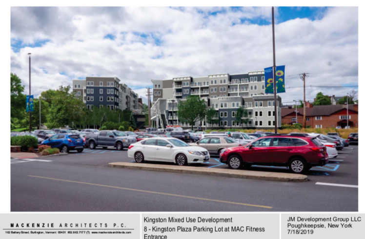
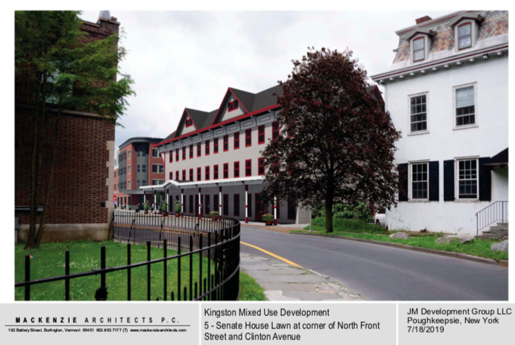
VISUAL IMPACT ANALYSIS: The Kingstonian Project
By Mackenzie Architects P.C.
“1895 to 1965 was considered to be the commercial heyday for this district. We believe that the introduction of neighborhood housing, restoration of a hotel presence, the addition of infill commercial uses along North Front Street and the discreet introduction of convenient parking will only serve to further enhance the viability of this district. We also believe that the creation of a public park to replace Fair Street will provide a valuable focal point for activities and a sense of place for the area as envisioned in the City’s Heritage Area Management Plan; it also provides an opportunity to preserve the views of the mountains to the north and a sense of transition offered by the original bluff edge of the stockade.”

Traffic Impact Study The Kingstonian
By Creithon Manning
“This report summarizes the results of a Traffic Impact Study completed for the proposed Kingstonian Mixed-use Development located in the City of Kingston, Ulster County, New York. The site is comprised of three parcels located on Fair Street Extension between N. Front Street and Schwenk Drive….The potential traffic impact of the proposed project was determined by documenting the existing traffic conditions in the area, projecting future traffic volumes, including traffic associated with other developments in the area, adding the peak-hour trip generation of the site, and analyzing the operating conditions of the study area intersections after development of the proposed project. Additionally, a sensitivity analysis considers the impacts of the project as they relate to proposed changes to circulation within the study area resulting from the Downtown Revitalization Initiative (DRI).”
Water Supply and Waste Water Capacity: The Kingstonian
By Brinnier & Larios, P.C.
“The Kingstonian Project is a proposed urban redevelopment project located at the former Uptown Kingston Parking Garage and the current Herzog’s Supply Company warehouse, and the Uptown Grill(see location map-Appendix A). The project encompasses 2.4 acres of land and a portion of Fair Street Extension.
The project is proposed to consist of the following elements:
- 129-131 Market Rate Residential Apartments
- 32 Room Hotel
- 8,000 Sq. Ft. of General Retail Space(mixed commercial use)
- 420 space parking garage
The purpose of this narrative is to outline the water and sewer requirements for the project and the general approach proposed for water supply and sanitary sewer service.”

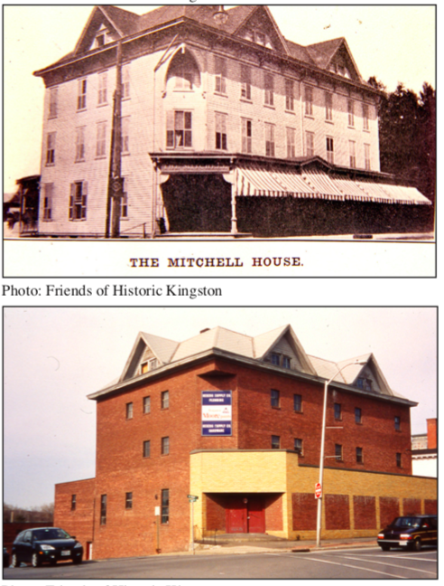
Demolition of the former Mitchell House (now Herzog’s Warehouse Building) at 17 North Front Street
Asbestos Abatement Air Sampling, Monitoring: 9 Front St. {Herzog’s Wearhouse} by Joseph P. Mcloughlin NYSDOL Monitor # L7-4292t
“I understand that the Planning Board had requested some information relative to the proposed demolition of our warehouse building at 9-17 North Front Street. In anticipatíon of the possible demolition of this structure in the future, we had an Asbestos Survey conducted in March 2018. Following completion of the survey, we had a complete asbestos abatement performed at 11/5/18 – 11/27/18…We understand that a demolition permit will be required prior to commencement of demolition activities. In reviewing the permit, it requires identification of a demolition contractor and notification to all utilities for disconnection of electric, gas, water and sewer to the building. The project is not yet advanced to the point where such an application can be made, but we would be happy to respond to any questions that the Planning Board might have pertaining to this matter.”
PRELIMINARY STORM WATER REPORT
By Brinnier & Larios, PC
Part 2: Appendix B
Part 3: Appendix C Custom Soil Resource Report
Part 4: Appendix D
Part 5: Appendix E
“The purpose of this report is to quantify and evaluate the impact of stormwater runoff generated by the proposed project. The method used in the report follows the urban hydrology model developed by the U.S.D.A. Soil Conservation Service known as the TR-55 (Technical Release 55) procedure for calculating storm runoff volume from small watersheds. HydroCAD computer software (Version 10.00), developed by Applied Microcomputer Systems, was used in computation of the hydrograph routing model. The analysis utilizes the 1, 10, 25 and 100 year-24 hour storm events to model pre- and post- development conditions. The design storms utilized in this analysis are from Cornell University’s Northeast Regional Climate Center (NRCC) precipitation database (http: I /precip.eas.cornell.edu /) . This database provides site-specific design storms, allowing us to more accurately model the hydraulic conditions at the project location. A full Storm Water Pollution Plan (SWPPP) is being be developed for the project. This report is intended to assess the project impacts so that a SEQRA determination can be made and to set the general groundwork for the SWPPP and SPDES General Permit requirements.”
GEOTECHNICAL REPORT
By Vernon C. Hoffman
Geotech 2: Results
Geotech 3: Presentation of Site Results
“The preliminary subsurface investigation for the proposed Kingstonian Development to be located at 19 North Front Street, Kingston, New York, has been completed. Six (6) soil borings have been completed by Northeast Specialized Drilling, Inc., of Liverpool, New York. Four (4) cone probes were done by Conetec, Inc., of West Berlin, New Jersey. At the one of these locations additional in-situ testing was done including shear wave velocity measurements, and Marchetti dilatometer tests. Pore pressure dissipation tests were performed at several locations to determine the depth of the groundwater table and estimate the drainage properties of the site soils. The logs of these borings, cone probe tests, and other in-situ tests, along with a location diagram, have been included in the appendix of this report.”
THREATENED AND ENDANGERED SPECIES HABITAT SUITABILITY ASSESSMENT REPORT
By Michael Nowicki
“A Habitat Suitability Assessment was completed on a 2.5+ acres site located at 9-21 North Front Street Mountain in the City of kingston, New York (Figure 1) for two federal and State listed species including the Indiana bat (Myotis sodalis) and Northern long-eared bat (Myotis septentrionalis) as per the US Fish and Wildlife Service (USFWS) list for the site (Attachment 1) and as per the New York State Department of Environmental Conservation (NYSDEC) Environmental Resource Mapper(Attachment2). A field assessment was conducted on July 6, 2019 to determine whether suitable habitat for these species is present on the site….The northern long eared bat requires/occupies practically the same habitat niche as the Indiana bat. There are no impacts to habitat and therefore no conservation measures required.”

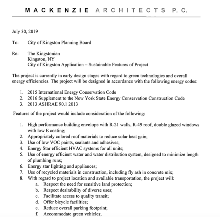
GREEN CONCEPTS LETTER
By Mackenzie Architects
